|
Interrogation Data |
|
Interrogation data, AKA observations, are the result of previously PIT-tagged fish passing near or through antennas powered by transceivers capable of decoding the unique ID of a PIT tag. An interrogation record consists of the site code and antenna identifier where the detection occurred, the date and time (in Pacific Standard Time) on which it occurred and the unique PIT tag code that was detected. Each site code represents a registered location for which a rich set of metadata is maintained, including location coordinates, antenna arrangement, operational status, contact information for the site operators, and diagrams/pictures.
PIT tag detection systems are capable of recording multiple detections of a single tag per second. These multiple tag reads are aggregated to the second and combined into one record in the database. Interrogation records can be viewed at the site, antenna group, or individual antenna level, providing different scales of travel information.
There are two broad categories of interrogation sites - large-scale and small-scale sites. Large-scale sites are generally located in mainstem hydropower facilities where dedicated power and communication lines can be installed and maintained. These systems monitor PIT-tagged fish traveling through juvenile bypass systems and adult fish ladders on the Columbia and Snake rivers and generate the bulk of interrogation records stored in PTAGIS
At large-scale sites managed by PTAGIS, PIT tag detections are collected and stored on a computer platform running PTAGIS software. Files are submitted automatically once per hour and the systems are continuously monitored by PTAGIS field operations staff.
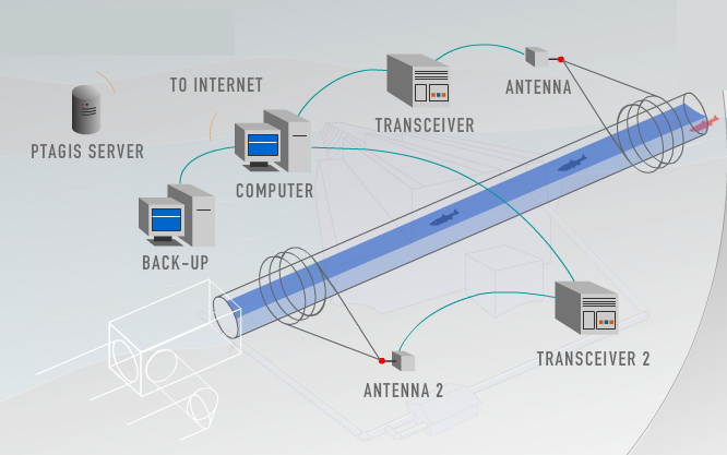
As RFID technology for research applications grew, researchers began to experiment with and install small-scale interrogation sites in different types of locations: hatchery and acclimation pond outfalls, hatchery return ladders, screw traps, weirs, in the beds of smaller tributaries, and even in a surface pair-trawl in the Columbia River estuary. These locations have a variety of power and connectivity challenges which are generating many innovations in how interrogation data are collected and submitted to PTAGIS. Some sites are able to submit data automatically, though the submissions schedule varies by site. Those sites which are unable to submit data automatically rely on personnel to visit the site before the detections can be submitted to PTAGIS.
PTAGIS operates multiple interrogation sites, primarily large-scale sites located in mainstem hydropower facilities. Several hundred other small-scale interrogation sites registered in PTAGIS are operated by other organizations throughout the Columbia Basin. Before using interrogation data from a particular site, it is important to understand the configuration and operations of that site. The primary source of information about any registered site can be found on the interrogation site metadata page. Interrogation site locations can be viewed on a simple web map or can be downloaded for use in GIS software.